
Rockhampton and Rannes, both established on riverbanks in Central Queensland, share a history shaped by the Fitzroy and Don rivers. This article traces the historic flooding of these two waterways — one at Rockhampton the other at Rannes — focusing on the personal and community stories of those impacted by these events.
Rockhampton is the main city and administrative centre of the Rockhampton Region, one of Queensland’s major local government regions, with a population of about 85,000. Rannes is located in the Banana Shire, 104 kilometres southwest of Rockhampton.
Once the administrative centre of the Banana Shire, Rannes is now a ghost town. All that remains are a handful of houses, rusty railroad tracks and scattered reminders of its former role as a busy railway hub. By contrast, Rockhampton is booming. The city is a thriving service centre for Central Queensland, with affordable housing, growing job opportunities and an economy anchored by mining, cattle, education, healthcare and defence.
Both settlements were established on the banks of a river: Rannes on the Don River and Rockhampton on the Fitzroy River. Heavy seasonal rainfall across their catchments makes both rivers subject to flooding. The Fitzroy River is Central Queensland’s major waterway, formed near Duaringa by the confluence of the Mackenzie and Dawson rivers and fed by six main river systems: the Isaac, Nogoa, Comet, Connors, Mackenzie and Dawson. Its vast fan-shaped catchment covers approximately 142,665 km² (55,083 sq mi), which contributes to frequent, sometimes severe flooding.

The major rivers in the Fitzroy Basin.
Source: The Fitzroy Contaminants Project – A study of the nutrient and fine-sediment dynamics of the Fitzroy Estuary and Keppel Bay – Scientific Figure on ResearchGate.
The Don River is a significant tributary of the Dawson River, joining it just north of Baralaba. While the great Fitzroy floods at Rockhampton have been carefully recorded since 1859, the floods of the Don at Rannes have not been given the same attention. Yet their impact on the district has been profound. By writing about these events, I seek to correct this imbalance — to ensure that the stories of the Don River and the people who lived near it at Rannes are not lost to time.
My connection to Rockhampton and Rannes
I have four reasons for writing about these places.
First, in the 1850s, Rockhampton and Rannes stood at the frontier of European settlement in Central Queensland. The decisions made there — where to settle, how to use the land, how to navigate the rivers — set the course for the region’s development and left a legacy that still echoes through the districts today.
Second, my maternal ancestors were among the early European settlers of the Rockhampton and Rannes districts. In 1858 my great-great-grandfather Alfred Beaumont joined approximately 15,000 prospectors who flocked to Canoona, northwest of Rockhampton, in search of gold. Alfred and his wife Emma came to Sydney, Australia, from England in 1853. Emma and the couple’s children joined Alfred in Rockhampton in 1859.
The Canoona gold rush lasted just two or three months. Alfred, like many of his disappointed contemporaries, sought employment in the Rockhampton area. In 1860, he obtained work on Calliungal, a huge pastoral lease whose head station was located about 55 miles (72 kilometres) southwest of Rockhampton. Calliungal extended from Mount Morgan in the north to Rannes in the south, east to the Don River and west almost to Westwood.
In 1863, Alfred purchased a couple of blocks of land near a small settlement called Dundee (later renamed Deeford). Deeford lies on the banks of the Dee River, about 50 miles (80 kilometres) southwest of Rockhampton, near the present-day town of Wowan.
Thomas Bloomfield Beaumont, Alfred’s eldest son and my great-grandfather, worked as a teamster and stockman. He started working with a team of bullocks out of Gladstone at the age of 9. By 1875, Thomas was head stockman on Calliungal Station. From the late 1800s, Thomas and his sons ran a carrying business from their base at Westwood, working with teams of horses and transporting goods across Central Queensland. In 1912, Thomas and his son Donald (my grandfather) purchased undeveloped prickly pear blocks near Rannes and moved there in early 1915.

Third, in 1946, after the war, my parents settled in Rockhampton. They lived there for the remainder of their married life (53 years). I was born and raised there and later returned to Rockhampton with my husband and family. We lived there from 1984 to 2002.
Fourth, interest in Rannes is strong. Whenever I post an article about Rannes on my Love in a little black diary Facebook page, the response (likes, comments, shares) is overwhelming. Many readers share their experiences and memories of Rannes and district while others simply want to know more of its story. One reader wrote to me personally, recounting a tragic event that occurred during historic flooding of the Don River at Rannes. I will share that story later in this article.
The early days of Rannes and Rockhampton
European settlement at Rannes predates that of Rockhampton.
In March 1853, the Leith Hay brothers — James, Norman and Charles — took up a huge pastoral run in the Don and Dee rivers catchment. They named it “Rannes” after one of the Leith Hay family estates in their native Scotland. They also named the Don and Dee rivers after rivers in Scotland. At the time, Rannes was the most northerly settlement of the colony of New South Wales.

In 1853, Scottish-Norwegian pastoralists Charles and William Archer travelled north from the Burnett district, where they had settled with their flocks and herds. They passed through the land taken up by the Leith Hay brothers. The Archers were following reports of the country by explorer Dr Ludwig Leichhardt, who in 1844 crossed and named the Dawson, Mackenzie and Isaac rivers. Leichhardt believed that the Dawson and Mackenzie rivers joined to form a larger stream. In 1853 the Archer brothers identified that watercourse and named it the Fitzroy, after Sir Charles Fitzroy, then governor of New South Wales. The Archers returned to the Burnett.
In July 1855, Charles Archer came back to the Fitzroy River district. He led a party — with Henry Risien second in command — comprising sixteen Europeans, four native police and their wives and four other indigenous men. They brought with them several thousand sheep, bullock teams, horses and all the equipment they needed to reestablish themselves in a new location. They settled at what is now Gracemere, about 10 kilometres south of Rockhampton. Charles’ brother Colin led a second party from the Burnett a year later. Other European settlers followed, including the Elliott brothers in 1856.
Early Rockhampton
Between 1855 and 1856 Charles Archer assisted William Wiseman, Commissioner of Crown Lands for the Leichhardt District, choose the site for Rockhampton. The colonial government in New South Wales proclaimed Rockhampton a town in 1857. Francis Clarke commenced the town survey and A F (Francis Arthur) Wood, District Surveyor, completed it in 1858.
Wood, who had helped lay out the city of Melbourne, applied the Melbourne plan to Rockhampton: broad streets and narrow lanes alternating from east to west. According to J T S Bird in The early history of Rockhampton (1904), for many years those lanes were known as “little streets” (for example, Little Quay-street, now Quay Lane). Surprisingly, Little Quay-street remained the town’s principal thoroughfare for some years.
The town’s first allotments went on sale on 17 March 1858.
Commercial life began to take shape in the mid-1850s. In 1856, Richard Palmer opened Rockhampton’s first general store and built a small wharf on the riverbank at the bottom end of Fitzroy Street. Robert Parker established the town’s first hotel, the Bush Inn, on the riverbank above Palmer’s wharf. Palmer sold his business to his brother John in 1858; John Palmer later became Rockhampton’s first mayor, in 1861. [1]

The Bush Inn began as a modest single storey timber building but was considerably enlarged and improved after the Canoona gold rush. The hotel changed hands several times. In 1862, John Ward renamed it the Criterion. [2]

In 1890, Robert Parker’s daughter Dorinda Anne Curtis and her husband George Silas Curtis replaced the earlier structure with the handsome three-storied brick building that stands today. Local architect James Flint designed the grand building, one of Rockhampton’s enduring architectural landmarks. [3]
In the meantime, at Rannes much had changed.
In 1855, the New South Wales colonial government sent William Wiseman, Commissioner of Crown Lands, to Rannes to secure lease agreements for the crown land occupied by the Leith Hay brothers. To finance those leases, the Leith Hays entered a partnership with Sydney financier Thomas Holt. James Leith Hay married and moved to Ipswich, leaving Charles and Norman to manage Rannes and several other large runs they leased in 1855. James returned to Rannes in 1856 to allow his brother Charles to return to Scotland. Norman remained at Rannes.
Tragedy struck in April 1857 when Norman Leith Hay was aboard the ill-fated Sea Belle which disappeared while carrying wool from Rannes and Gracemere to Sydney via Gladstone. The vessel is believed to have been wrecked near the northern end of Fraser Island (K’gari). Neither the ship nor its passengers were ever found.
By 1858, James Leith Hay and Thomas Holt held leases on 39 blocks, including Rannes, Calliungal, Bananah, Harcourt, five Denby runs and others west of the Dawson River. This information is reliably reported in Two valleys – one destiny : a history of Banana, ‘shire of opportunity’ (2005). To finance their acquisitions, Leith Hay and Holt mortgaged the most profitable runs to Robert Towns (later, the founder of Townsville) and Alexander Stuart (Premier of New South Wales and head of its bank). In 1859, Towns and Stuart foreclosed. Towns bought Holt’s share and installed a manager at Rannes, bringing the Leith Hay era to an end. What began so optimistically for the Leith Hays, ended with a whimper.
James Leith Hay moved to Rockhampton where he served as sub-Commissioner of Goldfields (from 1858), sub-Commissioner of Crown Lands (from 1861) and as a magistrate in the Rockhampton courts.
Rannes township
Meanwhile, in July 1860, District Surveyor Francis Wood surveyed the town of Rannes. The Queensland Government gazetted the town reserve on 2 October 1860. The original site lay about 2 miles (3 kilometres) from the township that developed with the coming of the railway in 1912. Both sites bordered the Don River.
Rannes’s first licenced hotel appears in April 1863 when John Pendrigh opened the Netherby Arms. In November 1865 Alfred Roe applied to transfer the licence and operate it as The Rannes Hotel. [4]
Despite being gazetted, Rannes did not grow for several decades. Nearby Banana — originally an outstation of the Leith Hay’s settlement at Rannes — grew steadily after its first town lots went on sale on June 5, 1861. Banana later became the administrative centre of Banana Division (established in 1879) and subsequently Banana Shire (1903).
I’ve written previously and in detail about the early days of Banana in Secrets from the Banana Cemetery (April 2, 2019).
Gold discoveries at Rannes in late 1887 attracted about 200 itinerant prospectors, swelling the town’s population. In November 1887, the Great Kaufmann Gold Mining Company took leases on two areas of Rannes Station. [5]
At the time, Robert Stone held the licence of the Royal Hotel at Rannes. In April 1888, the licencing court at North Rockhampton approved Stone’s application for a licence to operate the Rannes Arms Hotel on Rannes Station. The same court received four other applications for licences to open hotels at Rannes, although it appears these applications were unsuccessful. [6] I’ve heard it said that Rannes had several hotels in its early days. If so, were they licenced establishments? I wonder.
In 1912, my maternal great-grandfather Thomas Bloomfield Beaumont and his son, Donald William, my grandfather, bought land near Rannes. Together with their families, they moved there from Westwood in early 1915. Here they established a dairy, small crop farming and a small cattle herd.
Rannes, a railway hub
Rannes began to grow from 1915, when the Dawson Valley railway line reached Rannes. The second stage of the Dawson Valley line from Rockhampton, Wowan to Rannes, opened on 2 February 1915. The Railways Department named the station Kuyul but renamed it Rannes a couple of months later, on 29 April 1915.
A postal receiving office and telegraph office opened at the Rannes railway station on 1 May 1915. The receiving office became a post office in March 1916. Successive stationmasters managed the town’s postal and telegraph services until 1923, when the services moved to a building in the main street, under Mr E S Stanley as postmaster. [7]
In September 1915, the Queensland Government auctioned 88 allotments in the new railway town of Rannes. [8] At the time, Rannes had no hotel or general store. [9] For a time Rannes served as the terminus of the railway from Mount Morgan (until 30 July 1917) and hosted a tent village of construction workers and their families beside the Don River. During this period, the town was abuzz with activity.


Rannes later became the junction for the Dawson Valley and Callide Valley branch lines. The Callide Valley line reached Callide on 3 May 1924 and Thangool on 24 August 1925. The Dawson Valley line from Rannes to Theodore opened on 7 May 1927. The government sawmill at Rannes turned out hundreds of thousands of timber sleepers for the expanding rail network.

Rannes’s growth peaked in the early 20th century. In 1930, the Banana Shire Council moved its offices from Banana to Rannes. The shire office remained there until 1944, relocating first to Wowan and then, in 1946, to Biloela. Also, in 1930 Charles (“Charlie”) Wilson opened the new Rannes Hotel, having purchased the building in Rockhampton and reconstructed it in Rannes’s main street opposite the railway station. [10]

The Fitzroy and Don rivers
The Fitzroy River is Central Queensland’s major waterway and the largest river system draining to the eastern coast of Australia. It enters Keppel Bay and the Coral Sea at Port Alma, roughly 50 kilometres from Rockhampton.
Its vast, fan-shaped catchment covers approximately 142,665 km² (55,083 sq mi) and comprises six main river systems: the Isaac, Nogoa, Comet, Connors, Mackenzie and Dawson. The Fitzroy itself is formed by the confluence of the Mackenzie and Dawson rivers near Duaringa, about 100 kilometres west of Rockhampton. This enormous catchment makes the river highly prone to severe flooding.
The Don and Dee rivers are two major tributaries of the Dawson River. Callide Creek also feeds into the Dawson, joining it via the Don.
The Don River rises in the Don River State Forest on the slopes of the Great Dividing Range west of Gladstone. It flows generally west and southwest, joined by 12 tributaries including the Dee River, before meeting the Dawson River north of Baralaba. Rannes sits on the banks of the Don, about 104 kilometres southwest of Rockhampton, and 40 kilometres east of Baralaba. The original township was established on the northern bank, while the later railway settlement sprung up on the southern side, roughly 2 miles (3 kilometres) from the first site.
The Dee River begins on the western slopes of the Razorback Range, near Mount Gavial about 20 kilometres south of Rockhampton. It flows through Mount Morgan, Dululu and near Wowan before joining the Don River close to Rannes.

Callide Creek is the principal waterway of the Callide Valley. It enters the Don River on a broad floodplain near Jambin, a small town in the Banana Shire located on the Burnett Highway between Biloela and Gladstone.
The junction of the Dee and Don rivers and Callide Creek lies within an expansive floodplain stretching between Wowan and Goovigen. This Dee-Don-Callide floodplain is approximately 37 kilometres long, up to 5 kilometres wide, and covers about 16,000 hectares.
The combined waters of the Don and Dee rivers and Callide Creek flow northward, draining into the Dawson River downstream of Baralaba, and from there ultimately into the Fitzroy.
Flooding of the Fitzroy at Rockhampton
Records of flooding of the Fitzroy River at Rockhampton date from 1859. Two of the earliest recorded floods occurred in 1864 and 1875.
In The early history of Rockhampton, J T S Bird (1904) describes the floods of 1864 and 1875 in detail. For many years the 1864 flood — or floods, for there were two that year — was referred to as “the big flood”. People dated other events by it: “It happened before the big flood,” or “just after”, Bird notes.
1864: “The big flood”
In 1864, the Fitzroy at Rockhampton flooded twice. Rain began on Christmas Eve 1863 and continued intermittently across Rockhampton and the Fitzroy catchment for weeks. Towards the end of January 1864, the rain intensified and fell almost continuously for a week. The Fitzroy at Rockhampton was already in flood and, with the inflow from its catchment areas, reached a peak on 20 February. It remained at that height for a couple of days before receding and, by the end of February, local conditions were improving.
Rain resumed on 4 March and continued for nearly a week. By 16 March the rain had eased at Rockhampton, but heavy upstream flows were moving down the Fitzroy. A violent storm on 17 March brought further heavy rain and destruction. The situation at Rockhampton was dire: the town was submerged and many flooded-out residents sought temporary accommodation in the town’s new jail and the Church of England building. On 19 March, the flooded Fitzroy reached a second, higher peak for 1864.
The flood of 1875
The 1875 flood was equally devastating, though it did not reach the 1864 high water mark. Heavy February rainfall across the Fitzroy catchment — especially in the Dawson and its tributaries — combined with intense local storms led to the flooding. On 21-22 February a storm at Rockhampton dumped 8 inches (200 mm) of rain in 24 hours, and by 26 February total rainfall at Rockhampton was estimated at 34 inches (854 mm). In the town reaches the Fitzroy peaked within 18 inches (0.46 m) of the 1864 mark, while in some outlying areas local rainfall caused water levels up to 12 inches (0.3 m) higher than in 1864. [11]
Subsequent “big” floods
After a lull of 15 years, Rockhampton endured a series of major floods in quick succession: 1890, 1893 and 1896 — three “big” floods in seven years — making flooding of the river a constant threat for residents of low-lying areas of the town.


The highest recorded flood at Rockhampton occurred in 1918, when the Fitzroy peaked at 10.11 metres. The river remained at about 7 metres for approximately 27 days and over 9 metres for 20 days, isolating the city for about a month. The impact of the flooding was catastrophic, both in the city and the surrounding districts. Eight people lost their lives.
The 1954 flood is the second highest on record, with a peak of 9.40 metres and more than 18 days above 7 metres. The third highest recorded flood at Rockhampton occurred in January 1991. More recent record floods of the Fitzroy occurred in 2011 and 2017.
Flooding has always been part of Rockhampton’s story. Long before I was born, the Fitzroy River had already shown its power — sometimes slowly, sometimes suddenly, but always decisively. Over the years, as I’ve learnt more about the city’s past and lived through some of its challenges myself, I’ve come to understand how deeply these floods shaped not only the landscape but also the people who call Rockhampton home.
The 1918 flood: Rockhampton’s biggest test
For the fledging city of Rockhampton, the 1918 flood was its biggest test. In January and February that year, flooding of the Fitzroy River resulted from a succession of severe weather events. Heavy rain over the Mackenzie River catchment early in January set the stage and, by 20 January, the Fitzroy had climbed high enough to completely submerge the city wharves.
That same evening, a tropical cyclone crossed the coast between Bowen and Rockhampton, causing widespread destruction and bringing torrential rain to Mackay and Rockhampton. Over just two days, 20-21 January, Rockhampton recorded 14½ inches (368 mm) of rain. As the cyclone moved inland, it drenched the already saturated districts of the Mackenzie. [12]
A later report [13] noted that the Dawson River was not in flood at the time and absorbed a tremendous volume of the water from the MacKenzie. Instead of flowing into the Fitzroy, some of the water flowed into the Dawson. This unusual phenomenon caused the Dawson to run up instead of down. Had this not happened, Rockhampton might have faced an even greater disaster.
The Fitzroy River at Rockhampton peaked at 10.11 metres on 2 February. Floodwaters lingered for weeks: the city wharves were submerged for 33 days, and the river stayed above 9 metres for 20 days and around 7 metres for approximately 27 days.


As the river approached its peak, floodwaters swamped the central business district despite extensive sandbagging. Businesses in Quay, East and William streets were inundated. Shopkeepers in East and William streets stacked their goods up high in an effort to save stock. Stores in the lower part of East Street suffered severe damage. The railway yards became a vast expanse of water, and floodwaters rose to the top of the Stanley Street railway station platform. [14]

Many residents of low-lying suburbs such as Depot Hill and Port Curtis were forced to abandon their homes. The river rose so rapidly that many were caught unprepared. The Police Commissioner and the Mayor coordinated the evacuation by boat of more than 1300 stranded residents. Some evacuees found shelter with relatives or friends on higher ground, while others were housed in public buildings – including the School of Arts, the Technical College, and various churches – opened specifically for emergency accommodation. [15]
Across the river in North Rockhampton, conditions were not much better. Moore’s Creek backed up from the Fitzroy, broke its banks, and flooded low-lying streets across Yaamba Road as far as Lakes Creek. Residents of Koongal and Kalka were among the worst affected. [16]
Rail services to and from Rockhampton were disrupted from 22 January. Telegraph and shipping services were also affected. Apart from limited rail services to the north, Rockhampton remained isolated for almost a month. Rail services between Brisbane and Rockhampton resumed on 16 February and services between Rockhampton and the west recommenced two days later.
The 1954 flood: Disaster on the eve of celebration
By the time the 1954 flood arrived, Rockhampton had already endured several major inundations.
But this flood could hardly have struck at a worse time. On 19 February, the Fitzroy River reached a peak of 9.40 metres, the second highest level ever recorded in the city. Less than a month later, on 15 March, Queen Elizabeth II and her husband Prince Phillip, Duke of Edinburgh, were scheduled to visit Rockhampton.
How could the city possibly recover in time for a royal visit? The people of Rockhampton and Central Queensland had been looking forward for months to the Queen’s visit. It was a once-in-a-lifetime event. The Queen’s 1954 tour, from 3 February to 1 April, marked the first time a reigning British monarch set foot on Australian soil, and anticipation was immense.
The Fitzroy remained above 7 metres for 18 days. The damage bill was staggering. Early estimates put the economic loss to Rockhampton at £1 million — an enormous sum, roughly $45 million today. This figure included not only damage to homes, roads and crops, but also the widespread loss of income suffered by local businesses and workers. The Central Queensland Meat Exporting Company (the Lakes Creek meatworks), then Rockhampton’s biggest employer, sustained heavy damage and was forced to close for up to six weeks for repairs. [17] For many families, that meant weeks of uncertainty.

As in 1918, hundreds of residents from low-lying suburbs had to be evacuated. More than 1000 homes were flooded. On 19 February, at a public meeting of concerned citizens, the city council established a Flood Relief Fund to support those most affected by the flooding. A committee was elected to manage the appeal, which drew donations from across Australia and raised just over £11,845 (more than $520,000 in 2026). Of 333 claims submitted, 307 were approved. [18] Those numbers say a lot about how many people were affected.

At the height of the flood, the floodwaters surrounded Rockhampton, cutting it off completely. For nearly a week, all road, rail and air transport in and out of the city ceased. The airport was closed when water up to 4 ft (1.2 m) deep covered the runways. With the Queen and her entourage due to arrive by air, the question loomed: Would the airport be ready in time? And what of the roads and rail services needed to bring the thousands who planned to travel to Rockhampton to catch a glimpse of the Queen?
My parents lived through the 1954 flood. Fortunately, our home in North Rockhampton was well away from the floodwaters. But my father’s business, Central Trading Co., in William Street, sat close to the rising river. His building escaped flooding, but he — like so many business owners — must have watched anxiously, day after day, as water entered the low-lying streets and lanes of the central business district.

Remarkably, despite the scale of the damage, Rockhampton recovered sufficiently to host the Queen’s visit on 15 March. A newspaper report [19] captured the mood of the day:

Local people regarded the Queen’s visit as a great honour, and thousands travelled from all over Central Queensland to greet the royal couple. My grandparents travelled from Rannes; many journeyed from much further afield. Special trains ran to accommodate the crowds. The official party of 250 included the mayors of Rockhampton and Gladstone, as well as the chairmen of all town and shire councils in Central Queensland and their wives.
It is estimated that Rockhampton’s population swelled from 40,000 to 70,000 that day. The airport and Town Hall became the main gathering points. Ten thousand people assembled at Connor Park airport. [20] Many royal enthusiasts — including my mother — camped out overnight near the Town Hall or the airport to secure a good vantage point.

Along the route from the airport to the Town Hall, hundreds waited patiently for hours to catch a glimpse of the royal couple. My mother told me that my grandfather, standing near the Town Hall, lifted my brother onto his shoulders so he could see the Queen as she passed by.

For the people of Rockhampton and district, the joy and pride of welcoming Queen Elizabeth II and the Duke of Edinburgh offered a much-needed moment of relief — an uplifting counterpoint to the hardship and loss brought by the devastating flood.
The 1991 flood: A memory of my own
By 1991, the Fitzroy had already carved its place firmly in Rockhampton’s history, but this time the story became personal. My husband Tony and I lived in Rockhampton at the time of the 1991 flood. We remember it well.
The Fitzroy River peaked twice. On Monday 7 January, it reached 9.15 metres, dipped slightly before rising again to a second, higher peak of 9.30 metres on Saturday 12 January. Since readings began in 1859, this was the third highest flood the city had experienced. The flooding followed very heavy rainfall in late December across the northern tributaries of the Fitzroy catchment, as Tropical Cyclone “Joy” weakened into a slow-moving rain depression.

The damage across the city was severe. Four people lost their lives. One man drowned while swimming in the Fitzroy River on 28 December 1990 and three men drowned when their boat capsized in floodwaters at Port Curtis on 9 January 1991. [21] The mirky water entered around 350 houses in low-lying suburbs such as Depot Hill, Port Curtis and Koongal. More than 1000 residents sought higher ground. All road and rail links to and from the city were cut and the airport closed to fixed wing aircraft. [22] We saw and experienced the impact of the flooding firsthand, as the following photographs of ours reveal.


One of the things Tony and I remember well is the foul smell of the stagnant water and the sludge left behind when the floodwaters receded. The humid, hot January weather made the stench worse. We felt so sorry for the people who lived in and near the affected suburbs where the smell lingered for months.
The river stayed above 8 metres for 13 days, leaving Rockhampton isolated for nearly three weeks. Travellers who happened to be in the city found themselves stranded, unable to leave. [23] Others who hoped to come simply couldn’t get through.
A family of four — friends of ours — were among those caught out. They were travelling from Bundaberg to their home in Townsville and stopped in to see us on Saturday 29 December 1990. The family had planned to continue their journey north the same day, but the roads were already cut. They ended up staying with us for four days, from Saturday 29 December to Tuesday 1 January, waiting for any route north (or even northwest) to open.
Other friends of ours, Rockhampton residents, were preparing for a family wedding scheduled for Saturday 5 January 1991. Because of the flooding, several out-of-town guests couldn’t get to Rockhampton. To fill the guest quota, the groom’s parents added Tony and me (and a few others) to the guest list — a small, unexpected joy in the middle of a natural disaster.
As always happened when the Fitzroy was in flood, Yeppen Lagoon on the southern outskirts of the city covered the Bruce Highway, the main road south, and the Capricorn Highway, the main road west. In 1991, there were no alternative routes; everyone simply had to wait for the water to go down. It would be another 25 years before the elevated Yeppen Floodplain Upgrade opened, in November 2015.
My husband and I were among the many residents, visitors and stranded travellers anxiously awaiting the reopening of the Bruce Highway. After being impassible for 11 days, the Yeppen Crossing reopened on Thursday 17 January. About 400 cars passed through in the first 45 minutes after the road reopened at 1.30 pm. “There were a lot of happy people leaving Rockhampton,” Senior Constable Bishop reported. [24] Tony and I, with our children, left for Brisbane the next day.

A river that shapes a city
Looking back across these three floods — 1918, 1954 and 1991 — I’m struck by how each one tells a different story, yet all share the same undercurrent of resilience. The Fitzroy has tested Rockhampton many times, but each generation has found its own way to endure, rebuild and carry on.
For me, these stories are not just historical accounts. They are part of my family’s memory, part of the city’s identity, and part of the reason Rockhampton feels like a place where people look out for one another when the river rises.
Historic flooding of the Don River at Rannes
The Don River at Rannes has always been a restless, unpredictable waterway. Those who lived there — my family among them — came to understand its extreme variability. The river can run low and quiet for long stretches, only to rise at astonishing speed when cyclonic or heavy rain falls in its catchment area. Its narrow bed and the flat country around it make the district particularly vulnerable to flooding. Over the years, the Don flooded often enough that evacuations at Rannes became a familiar ritual.
Record historical flooding of the Don River at Rannes occurred in 1862, 1875, 1928, 1942 and 1949. More recently, the river reached record heights again in 2013 and 2015, each time in the wake of a tropical cyclone that crossed the coast further north and weakened into a rain depression.
1862: The first great lesson
The flood of 1862 was the first great lesson for the early settlers. Bird (1904) wrote that the heaviest rains of the Fitzroy River catchment fell in late March and early April on the watersheds of the Dee and Don rivers and Callide Creek. Their combined inflow caused the Dawson River to flood. Around Rannes the rain was so heavy that the entire stretch of country from the Don to the Dee — 14 miles (22 kilometres) — lay underwater. At Rannes itself, the river rose to a height of more than 40 ft (12 m). [25]
It didn’t take long for newcomers to realise that the country between the Don and Dee rivers and Callide Creek is prone to sudden, dangerous flooding. Bird described the Don and its surrounds as “a very nasty piece of country to get caught in, as many have found to their cost.” His words were not an exaggeration.
1875: A second bitter lesson
The 1875 flood was another record one, remembered by inhabitants across the Dawson Valley. Heavy rain fell through the Fitzroy catchment, including the Dawson River and its tributaries and at Rockhampton itself. At Rannes, the Don rose with extraordinary force. Floodwaters were reported to have reached 25 ft (7.5 m) above the telegraph poles.
One old teamster recalled the scene vividly. [26] More than 40 bullock wagons, halted at the junction of the Don and Dee rivers, sat under water for several days. They were loaded with wool and station supplies. The Rannes Hotel, which stood nearby, was swept away entirely. When the waters finally subsided, the bodies of two yoked bullocks were found lodged in a tree nearly 50 ft (15 m) from the ground.
Floodwaters spread across a wide area, 6 to 20 ft (2-6 m) deep. Even Middleton’s hotel, perched on a ridge above the river on the northern side of the Don River bridge, could not withstand the force, The swollen river lifted the entire building off its foundations and carried it downstream. [27]
1928: “A very sorry spectacle”
By 1928, the people of Rannes and district already knew the Don River could rise quickly, but nothing prepared them for the devastation that followed the torrential April rains that year. Flooding swept through the Dawson Valley, leaving behind destruction and countless narrow escapes.

These newspaper headlines of 24 and 25 April captured the fear and uncertainty of the moment:
The flood left the township of Rannes in ruins. A reporter who visited shortly after the peak of the flooding described the scene as “a very sorry spectacle”. At that time, the township sat between the railway line and the river, below the railway station. In an earlier flood (1918), water had only just reached the shops; in 1928 it rose to 3 ft 6 in (a little over 1 m) at the railway station. [30]

The railway property suffered heavily. The stationmaster’s report to the general manager of the Central Division Railways [31] painted a grim picture:

Lower down, closer to the river, the destruction was much worse. Floodwaters reached a depth of 6 to 10 ft (2-3 m). The water inundated Hongie’s boarding house to a depth of 6 ft (2 m), damaging furniture and personal effects before the owners had time to remove them. The post office was swept up against the side of the boarding house. All records, equipment and communications were lost. For a time, Rannes was completely cut off. [32]
Anderson’s Fruit Shop in the main street was also overwhelmed. Fortunately, Anderson and his staff removed most of the stock before abandoning the building. As the water reached the town, it carried cattle caught further upstream. One of these beasts drowned in the fruit shop kitchen. Another ended up lodged in the stationmaster’s house. The force of the floodwaters washed a nearby house off its blocks, smashed it to pieces and carried it downstream. [33]
The government sawmill was completely destroyed. Every building collapsed, machinery was ruined, and water marks 20 ft (6 m) high on the posts of the railway water tank showed just how high the torrent had surged. [34]

Almost every selection around Rannes suffered losses. Crops, stock and fencing were swept away. The manager of Calliungal Station, just outside Rannes, reported the worst of it [35]:
North of Rannes, where the Dee and Don rivers meet, the water reached astonishing heights — sweeping over telephone poles and trees. Cattle were later found suspended in trees 20 to 30 ft (6-9 m) above the ground. [36]

My own family’s properties lay south of Rannes, off the Rannes-Banana Road near Woolein Creek. They were fortunate. Although backflow from the Don may have reached low-lying parts of their land, it is unlikely the main floodwaters reached them.
1942: A flood my family lived through
Following their marriage in 1937, my Uncle Harold and his wife Dulcie settled in Rannes. They lived through two of the town’s worst floods — 1942 and 1949. Thankfully, they built their home on the high side of the railway line, well above the flood level reached in 1928. I’ve shared a little of their story previously, in Auntie Dulcie and the Bung-in Cake (April 14, 2016).
In February 1942, an unnamed tropical cyclone crossed the coast near Cardwell, North Queensland, before looping back out to sea north of Mackay. The rain it delivered caused serious flooding in the lower reaches of the Fitzroy River catchment. Severe flooding of the Don and Dee rivers required both Rannes and Wowan to be evacuated.
At Rannes, the Don River rose to 46 ft (14 m), breaking the 1928 record by 2 ft 6 in (0.762 m). The rail and road bridges disappeared beneath the torrent. At a point opposite the township, the river spread more than a mile (1.6 km) wide. Fearing the river might rise even higher, residents fled to higher ridges, spending a night and a day on a mail train stranded 2 miles (3 km) from the town. [37]
The damage was immense. Hundreds of cattle were washed away, and no fewer than 17 beasts were later found caught in trees up to 40 ft (12 m) above the ground. [38]
In the township, water flooded many buildings. The railway station and office were covered to a depth of about 2 ft (0.6 m). The stationmaster, Mr P Crompton, lost most of his personal belongings and all his furniture. Floodwaters filled the entire ground floor of the Rannes Hotel. Mr T Williams’ store and post office were flooded to the second storey, destroying stock and personal property. The butcher shop was demolished and numerous outbuildings, sheds and garages were swept away. [39]
The following photographs, from the Beaumont Family archives, are most revealing. They show just how high the floodwaters reached in the town and in the surrounding district.
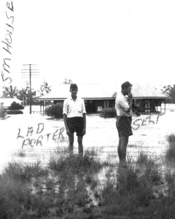


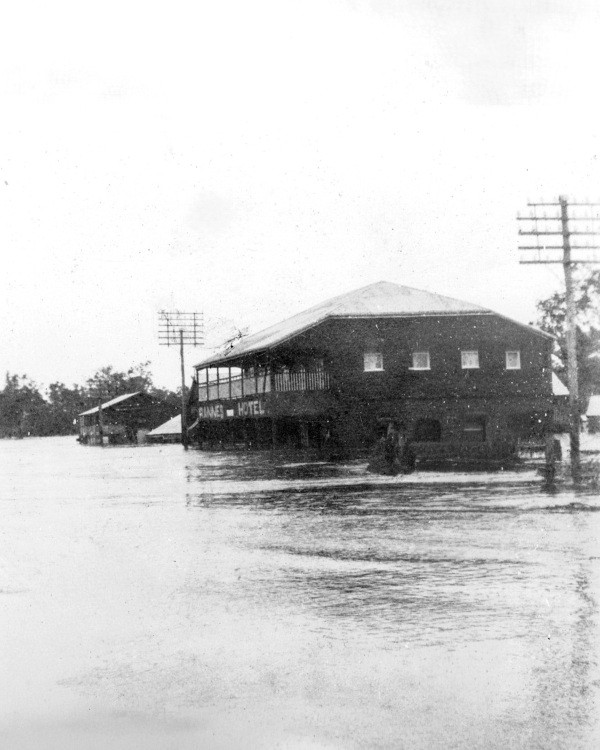


Roads, bridges, fences and telephone lines were badly damaged. Rannes had no communication with the outside world for nearly a week.
Yet even in the midst of hardship, there were moments of wicked humour. When the flood waters receded, locals spotted a 5-gallon (23-litre) cask perched 40 ft (12 m) up in a tree. Hopes rose — only to be dashed when the Rannes Hotel licensee retrieved it, discovering it was full of rum and worth about £20. There would be no free rum that day. [40]
1949: Another cyclone, another flood
Just as in 1942, the 1949 flood at Rannes followed heavy rainfall in the wake of a cyclone. At Mount Morgan residents endured a terrifying night as the storm raged without pause. A staggering 12.75 inches (324 mm) of rain fell overnight and into the next day. The Dee River burst its banks at several points. At Deeford (near Wowan) the river covered the traffic bridge by 14 ft (4.3 m). [41]
At Rannes, the Don River rose again, flooding the township and covering the road and rail bridges. Rail traffic between Rockhampton and the Dawson and Callide Valleys came to a halt. When linesmen inspected the railway several days after the river peaked, they found the rail bridge still under by 8 ft (2.4 m) of water. [42] Many roads throughout the Wowan-Rannes district were impassable.
Rannes suffered yet another inundation. Many buildings, including the Rannes Hotel, were flooded. Fortunately, the water did not reach the heights of 1942. In the hotel, for example, the water level was 2 ft (0.6 m) lower than in the earlier flood. [43]
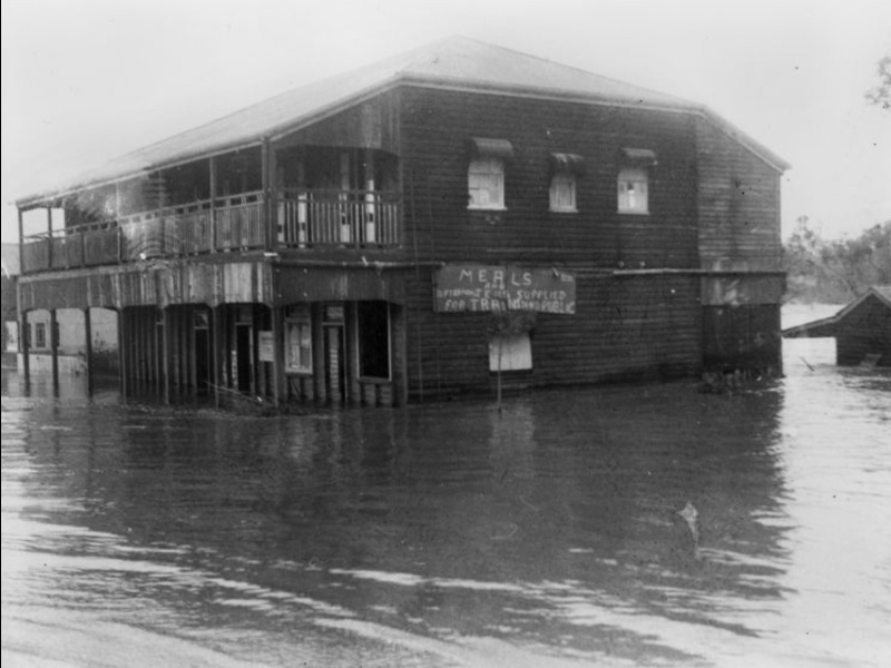
District properties were hit hard. The Don and Dee rivers swept away cattle, damaged crops and tore down miles of fencing. Some low-lying properties were completely washed out. [44]
Flooding of the Don: A perilous river crossing
From the earliest days of settlement, both the road and rail bridges over the Don River at Rannes were notoriously vulnerable to flooding. Even a moderate rise in the river was enough to cover the bridges, cutting off the township and placing travellers at considerable risk.
It wasn’t until 2015 that the Queensland Main Roads Department finally replaced the original low-level timber road bridge with three higher concrete structures, greatly improving flood immunity for travellers on the Leichhardt Highway. Earlier generations, however, had no such protection.

One of the most tragic instances of this vulnerability occurred on Thursday 8 March 1956, when a seasoned local traveller attempted to cross the flooded Don River. The following account is drawn from a contemporary newspaper report. [45]
Cornelius (“Con”) Marrinan, aged 62, manager of the Bank of New South Wales at Wowan, drowned when his utility truck left the submerged bridge and plunged into the fast-flowing Don River. The accident occurred at about 4.30 pm, when the bridge was covered by about 1 ft (0.3 m) of water.
Mr Marrinan was returning from his weekly visit to customers at Goovigen. Having managed the Wowan branch for 18 years, he was familiar with the Don River’s moods and had crossed the flooded bridge many times. In fact, he had crossed it safely earlier that same day, when the water was about 2 ft (0.6 m) over the decking.
His disappearance was not realised for several hours. Concern first arose when Rannes locals found Mr Marrinan’s dog — his constant travelling companion — alone on the riverbank near the bridge. At dusk, a railway night officer at Rannes noticed something submerged near the crossing and alerted the Wowan police, who promptly organised a search party.
Late into the night, a police-recruited diver found Mr Marrinan’s vehicle about 30 ft (9 m) downstream. The cabin was empty and the passenger door was open. The search continued through the night.
Early the next day, Mr Marrinan’s body was found lodged against a dead tree, roughly 100 yards (90 m) downstream. It was a tragic and undignified end for a highly respected local identity and World War I veteran.
Two postscripts add further poignancy to this event.
The first concerns Len Marrinan, a railway cleaner at Emerald and son of the deceased. Unaware of the accident, that same evening he was driving home to Park Avenue, Rockhampton, via Baralaba. Arriving at the Don River crossing at Rannes around 10.00 pm, he walked onto the bridge to test the depth of the water. There he encountered a staff member from the Wowan bank, who told him that his father was missing. Len Marrinan learned of his father’s fate at the very place where the tragedy occurred. [46]
The second postscript comes from the daughter of one of Con Marrinan’s clients, Beverley Tennent (nee Manion), who shared her recollection with me in a letter in November 2025.
She remembered Mr Marrinan’s regular visits to their farm, where he and her father would talk business, weather, politics, and family matters. Beverley, as a girl, would sit close by, listening intently. Her mother always offered smoko — freshly made scones with buttermilk from the morning’s milking, and cream churned into butter, one of Beverley’s favourite jobs.
On the day of the accident, time slipped by and eventually Mr Marrinan said he needed to leave. He intended to go straight home, though he may have had other clients to visit. Beverley’s father urged him to reconsider travelling, warning that the Don River was running very high after heavy rain. But Mr Marrinan insisted he had appointments to keep.
Beverley offered to open the railway gates on their property — the train line ran through their farm — and he thanked her. As she closed the gates behind him, she called out, “Be careful.” She did not know she would be the last person to speak to him.
Decades later, at the 75th anniversary of the Goovigen State School in 2001, Beverley recounted this memory during a conversation about travelling salesmen who visited farms. One woman mentioned that her father, Con Marrinan, had been a bank manager who travelled the district. Beverley replied that she had met him on the day the Don River at Rannes was in flood. The woman burst into tears, explaining that her father had been washed off the bridge and never found alive.
When Beverley told her that she had opened the railway gates for him and begged him to be careful — and that she had been the last person to speak to him — the woman embraced her, crying and smiling at once. “Thank you,” she said. “We never knew that. Thank you for your kindness.”
Reflection
Looking back across these stories — the early settlers learning the hard lessons of 1862, 1864 and 1875, the devastation of 1918 and 1928, the floods my own family lived through in 1942, 1949 and 1954, and myself in 1991 — I’m struck by how closely the life of this region has always been tied to its rivers. The Don and the Fitzroy have shaped not only the landscape but the character of the people who called Rannes and Rockhampton home. Each flood left its mark: on the towns, on the countryside, on the families who stayed and rebuilt, and on the memories passed from one generation to the next.
In retelling these histories, I believe I’m not just recording events, but honouring a way of life forged in courage and resilience — a reminder that in Central Queensland the rivers have always been both our greatest threat and our greatest inheritance.
REFERENCES
MAIN SOURCES OF INFORMATION
Bird, John T. S. (1904). The early history of Rockhampton: dealing chiefly with events up till 1870. J T S Bird. Rockhampton: The Morning Bulletin.
Bureau of Meteorology. (n.d.). Queensland flood history. Australian Government. https://www.bom.gov.au/qld/flood/fld_history/index.shtml
Frew, J. (1981). Queensland post offices 1842-1980 and receiving offices 1869-1927 / Joan Frew.J. Frew. http://hdl.handle.net/10462/comp/12599
Long, W. J. (1962). The early history of Mount Morgan, Dawson and Callide Valleys / compiled by W.J. Long. W.J. Long.
McDonald, L. (1988). Rockhampton & District : a pictorial history / foreword by Lorna McDonald. (2nd ed.). Oxford Press.
Perry, Betty & Banana (Qld.) Council. (2005). Two valleys – one destiny : a history of Banana, ‘shire of opportunity’ / by Betty Perry. Biloela, Qld. : Banana Shire Council.
Queensland Wetlands Program, author, & Queensland. Department of Environment and Science, issuing body. (2019). Case study : managing cattle and wetlands where three rivers meet on the Calliungal floodplain. [Department of Environment and Science]. https://nla.gov.au/nla.obj-1812942706
Newspaper articles found in Trove reproduced courtesy of the National Library of Australia. https://trove.nla.gov.au/
Webster, Barbara. (2010) ‘Rockhampton’s great flood of 1918’. In The Queensland Historical Atlas: Histories, Cultures, Landscapes. https://www.qhatlas.com.au/content/rockhampton%E2%80%99s-great-flood-1918
SPECIFIC REFERENCES
Click here for list
- DEATH OF MR. R. E. PALMER. (1903, November 6). The Morning Bulletin (Rockhampton, Qld. : 1878 – 1965), p. 5. Retrieved January 24, 2026, from http://nla.gov.au/nla.news-article52995670
- Advertising (1862, August 6). Rockhampton Bulletin and Central Queensland Advertiser (Qld. : 1861 – 1871), p. 1. Retrieved January 22, 2026, from http://nla.gov.au/nla.news-article51555975
- Rockhampton Improvements. (1890, September 4). The Daily Northern Argus (Rockhampton, Qld. : 1875 – 1896), p. 3. Retrieved January 22, 2026, from http://nla.gov.au/nla.news-article213458486
- ANNUAL LICENSING MEETING. (1863, April 25). Rockhampton Bulletin and Central Queensland Advertiser (Qld. : 1861 – 1871), p. 1 (SUPPLEMENT TO THE BULLETIN.). Retrieved January 19, 2026, from http://nla.gov.au/nla.news-article51557921
- RANNES GOLDFIELD. (1888, February 9). The Morning Bulletin (Rockhampton, Qld. : 1878 – 1965), p. 5. Retrieved January 22, 2026, from http://nla.gov.au/nla.news-article52014075
- NORTH ROCKHAMPTON RENEWALS. (1888, April 5). The Daily Northern Argus (Rockhampton, Qld. : 1875 – 1896), p. 2. Retrieved January 19, 2026, from http://nla.gov.au/nla.news-article213452958
- POSTAL FACILITIES AT RANNES. (1923, August 18). The Capricornian (Rockhampton, Qld. : 1875 – 1929), p. 67. Retrieved January 28, 2026, from http://nla.gov.au/nla.news-article72198752
- AUCTION SALES OF LEASES. (1915, September 3). The Week (Brisbane, Qld. : 1876 – 1934), p. 4. Retrieved January 18, 2026, from http://nla.gov.au/nla.news-article181474263
- “RANNES NOTES.” Daily Record (Rockhampton, Qld. : 1897 – 1922) 2 November 1915: 5. Web. 19 Jan 2026 http://nla.gov.au/nla.news-article291627725
- RANNES (1930, February 20). The Central Queensland Herald (Rockhampton, Qld. : 1930 – 1956), p. 43. Retrieved January 29, 2026, from http://nla.gov.au/nla.news-article70267902
- THE FLOODS AT ROCKHAMPTON. (1875, March 13). The Queenslander (Brisbane, Qld. : 1866 – 1939), p. 2. Retrieved January 16, 2026, from http://nla.gov.au/nla.news-article18335125
- CYCLONIC STORM IN ROCKHAMPTON. (1918, January 22). The Morning Bulletin (Rockhampton, Qld. : 1878 – 1965), p. 7. Retrieved January 23, 2026, from http://nla.gov.au/nla.news-article53835757
- WHAT HAPPENED IN FLOOD OF 1918 (1949, March 8). The Morning Bulletin (Rockhampton, Qld. : 1878 – 1965), p. 5. Retrieved January 23, 2026, from http://nla.gov.au/nla.news-article56896673
- ROCKHAMPTON’S DANGER. (1918, February 1). The Daily Mail (Brisbane, Qld. : 1903; 1916 – 1926), p. 5. Retrieved January 23, 2026, from http://nla.gov.au/nla.news-article220495519
- Webster, Barbara. (2010) ‘Rockhampton’s great flood of 1918’. In The Queensland Historical Atlas: Histories, Cultures, Landscapes. https://www.qhatlas.com.au/content/rockhampton%E2%80%99s-great-flood-1918
- ROCKHAMPTON’S DANGER. (1918, February 1). The Daily Mail (Brisbane, Qld. : 1903; 1916 – 1926), p. 5. Retrieved January 23, 2026, from http://nla.gov.au/nla.news-article220495519
- Rockhampton Flood Damage Estimated At £1 Million (1954, February 21). Truth (Brisbane, Qld. : 1900 – 1954), p. 8. Retrieved January 30, 2026, from http://nla.gov.au/nla.news-article201194343
- FLOOD RELIEF FUND BALANCE BASIS OF PERMANENT FUND (1954, June 2). The Morning Bulletin (Rockhampton, Qld. : 1878 – 1965), p. 9. Retrieved January 31, 2026, from http://nla.gov.au/nla.news-article57320780
- ROYAL COUPLE WELCOMED AT ROCKHAMPTON (1954, March 16). The Townsville Daily Bulletin (Qld. : 1907 – 1909 ; 1912 – 1966), p. 1. Retrieved January 24, 2026, from http://nla.gov.au/nla.news-article62513856
- Ibid.
- One body found, two men still missing in Rockhampton flood (1991, January 11). The Canberra Times (ACT : 1926 – 1995), p. 3. Retrieved January 23, 2026, from http://nla.gov.au/nla.news-article122336442
- Homes evacuated as Fitzroy rises (1991, January 5). The Canberra Times (ACT : 1926 – 1995), p. 3. Retrieved January 23, 2026, from http://nla.gov.au/nla.news-article122335177
- 500 floodbound in Rocky, Mackay (1990, December 31). The Morning Bulletin (Rockhampton, Qld.).
- Rapid exodus as highway is reopened (1990, January 18). The Morning Bulletin (Rockhampton, Qld.).
- ROCKHAMPTON. (1903, April 4). The Capricornian (Rockhampton, Qld. : 1875 – 1929), p. 9. Retrieved January 17, 2026, from http://nla.gov.au/nla.news-article71947386
- CARRIERS OF THE PAST. (1928, April 24). Daily Mercury (Mackay, Qld. : 1906 – 1954), p. 5. Retrieved January 17, 2026, from http://nla.gov.au/nla.news-article175822721
- THE FLOODS AT ROCKHAMPTON. (1875, March 13). The Queenslander (Brisbane, Qld. : 1866 – 1939), p. 2. Retrieved January 4, 2026, from http://nla.gov.au/nla.news-article18335125
- DISASTER FEARED (1928, April 24). The Telegraph (Brisbane, Qld. : 1872 – 1947), p. 9. Retrieved January 28, 2026, from http://nla.gov.au/nla.news-article179329258
- DISASTROUS FLOOD. (1928, April 25). The Brisbane Courier (Qld. : 1864 – 1933), p. 15. Retrieved January 28, 2026, from http://nla.gov.au/nla.news-article21246188
- RANNES. (1928, May 3). The Capricornian (Rockhampton, Qld. : 1875 – 1929), p. 23. Retrieved January 28, 2026, from http://nla.gov.au/nla.news-article69851539
- DAMAGE AT RANNES. (1928, April 26). The Toowoomba Chronicle and Darling Downs Gazette (Qld. : 1922 – 1965), p. 7. Retrieved January 28, 2026, from http://nla.gov.au/nla.news-article254029052
- RANNES. (1928, May 3). The Capricornian (Rockhampton, Qld. : 1875 – 1929), p. 23. Retrieved January 28, 2026, from http://nla.gov.au/nla.news-article69851539
- Ibid.
- Ibid.
- APPALLING LOSSES. (1928, May 1). Queensland Times (Ipswich, Qld. : 1909 – 1954), p. 7 (DAILY.). Retrieved January 4, 2026, from http://nla.gov.au/nla.news-article114196903
- Ibid.
- FLOOD DAMAGE (1942, February 18). The Morning Bulletin (Rockhampton, Qld. : 1878 – 1965), p. 6. Retrieved January 4, 2026, from http://nla.gov.au/nla.news-article56110618
- Ibid.
- ‘COUNTRY NEWS’. In Central Queensland Herald (Rockhampton, Qld. : 1930 – 1956), Thursday 19 February 1942, page 24. Online: https://trove.nla.gov.au/newspaper/article/76233457
- Ibid.
- NIGHT OF TERROR AT MT MORGAN (1949, March 4). The Morning Bulletin (Rockhampton, Qld. : 1878 – 1965), p. 6. Retrieved January 29, 2026, from http://nla.gov.au/nla.news-article56896334
- SOME RIVERS HIGHER, OTHERS FALLING RAPIDLY (1949, March 7). The Morning Bulletin (Rockhampton, Qld. : 1878 – 1965), p. 1. Retrieved January 29, 2026, from http://nla.gov.au/nla.news-article56896507
- TWO LADS MISSING IN FLOOD (1949, March 7). Maryborough Chronicle (Qld. : 1947 – 1954), p. 3. Retrieved January 4, 2026, from http://nla.gov.au/nla.news-article147535496
- GENERAL FLOODING THREATENS CALLIDE-DAWSON AREAS (1949, March 5). The Morning Bulletin (Rockhampton, Qld. : 1878 – 1965), p. 1. Retrieved January 23, 2026, from http://nla.gov.au/nla.news-article56896382
- Drowning In Flooded River at Rannes (1956, March 15). The Central Queensland Herald (Rockhampton, Qld. : 1930 – 1956), p. 11. Retrieved November 19, 2025, from http://nla.gov.au/nla.news-page7494866
- Ibid.


Dear Judith,
Congratulations on having your information recorded on the web resource in the State Library of QLD. It is nice to think it has been preserved for the future generations.
I read with interest your latest blog on Rockhampton and Rannes.
It brought to mind a story told by my grandmother (your great aunt, Hannah Beaumont.)
In the early 1900’s when Hannah was living near Rannes, she had a lucky escape when crossing the river in her horse drawn buckboard.
Nothing was unusual as she entered the river bed at the local crossing. However on reaching the half way point, she was surprised to find herself in the middle of a flash flood powering down the river at great speed. Suddenly her rig was surrounded by fast moving water and it was getting deeper!
Luck was on her side that day as two men on the far bank swam their horses out to rescue her and her horse.
Being a dainty Victorian Lady by nature, all modesty went down the creek as she climbed astride behind the gentleman on his horse. She clung on for dear life as his horse swam them to safety.
Sobering thought……. I might not be here at all if it had been a different outcome!!
Megan, thank you so much for responding to my account of historic flooding of the Fitzroy and Don rivers. Your story about your grandmother, Hannah Beaumont (my great-aunt), is most revealing, and I’m so glad you’ve shared it with my readers. It shows just how rapidly the Don River can rise without warning, with the water flowing rapidly downstream as a result of a downpour in the catchment higher up. Thankfully, the men were there to rescue Hannah and she lived to tell the story.
Hello Judy, I was born in Biloela in 1935, and my Father was Ganger of No 3 Gang, Callide Valley Line, for 30 Years, so with every flood, from 1942, to 1962, I was familiar with the risk that he, and his men took, in clearing the Callide and Kroombit Railway bridges, as soon as the water was clear of the rails, and in running the line, between Thangool and Argoon, as soon as the rails were clear of water. Also, after the 1942 flood, the Railway Dept. Put the Jambin Railway houses up on 10 Foot Concrete stumps, to keep them clear of future floods. Also, in 1954, I was working in Mt. Morgan, and the closest that we could get to Rockhampton was the top of Egans Hill. There was a lot of water around.
John, thank you for explaining how you know so much about flooding in the Callide Valley. You and your family have lived through many floods! What stories you could tell. I do hope you have recorded at least some of them. Kind regards, Judy.
My mother was the Railway Station Mistress at Goovigen, at the time of the 1928 flood, and my father was fairly involved with other Goovigen men, in work associated with the flood The tin bath was taken from the Railway Station House, and used as a makeshift boat. One thing that was missing from your account, was that flood conditions, during the 1928 flood, were compounded by the top 3 feet of the dam wall, on the Dee River, above Mt Morgan, broke away, and a huge wall of water went down the Dee, washing buildings away at Tipperary Flat, and also, at Dululu drowned, I think, a complete Family, who were camped near the River. When that water joined the Don, on the Calliungal Flats, it added greatly to the flooding at Rannes. My late wife’s family had a farm at Buneru, between Wowan and Rannes, and Jean’s Father could talk a lot, about the ’28 flood.
John, you are a source of much information. Thank you so much for being willing to share this with my readers. I’m so glad you remember all these details of the historic floods of the Don-Dee-Callide waterways. I encourage you to record all of this information while you have the opportunity. We do not want it to be lost to future generations. My best wishes, Judy.
I was thrilled to hear from you. The historical stories, the devastating floods, the rivers, even old photos of places and buildings are so educational and very interesting. I loved to hear about your family so near to my family near Ramnes
Poor Rannes, people who suffered yet bounced back and rebuilt their buildings and lives. How wonderful to be an Australian, we are ever ready to help our neighbour and friends, even strangers. I saw the Queen and Prince Phillip the day they visited Rockhampton, my family was at my Aunts and we were but a few feet away from the Royals. We had forgotten our hats in our rush to leave our farm Shandon Vale so Mum made us hats from the Morning Bulletin newspaper. We must have looked a sight!
Speaking of the flood in Rockhampton where the vegetation was an overpowering stench, we had driven in from Blackwater and I became very unwell. I overheard a visitor at The Wagon Wheel Service Station and Cafe say they would never come back. I thought that was unfair it wasn’t Rockhampton’s fault. Thank goodness for Rex Pilbeam the then mayor, who was responsible for the Barrage thst has saved Rockhampton from being so badly flooded.
God bless Judy you have done a magnificent job. Regards Bev Tennent.
Dear Bev. Thank you so much for your personal and most informative comments. Yes, we share connections to Rannes via our families, who knew each other well. How special it is that you and I have now made a connection. I’m so grateful for the memories you’ve shared with me, such as the one I’ve included in this article. It is so important that we record these memories, for those that come after us.
I was interested to read that you had the opportunity to see Queen Elizabeth and Prince Phillip during their visit to Rockhampton in 1954. How special was that. And I love the bit about the hats! Thanks also for sharing the snippet about the 1991 Rockhampton flood and the stench. That certainly puts a different slant on the matter.
Thank you once again for your encouragement and loving feedback. xx
It was good to read about the numerous rivers and area that they covered.The Canoona gold rush sounde like it was a bit of a fizzer.Rannes being part of the colony of NSWales was ununexpected.It was a large railway constructetion camp at Rannes .Nice to see the gardens around the station and the cream cans on the platform. Rockampton and Rannes both suffered from some bad flooding. seeing the lad porter bought back some memorties to me that was me 19th Fefruary 1959 at Childers.qld.