
Last October, during a visit to outback Queensland, my husband Tony and I included the tiny town of Windorah in our itinerary. What a good decision that was! We discovered a neat well-kept town rich in history and a community that honours its forebears and cares passionately for its extraordinary natural environment. In this post I take you on a virtual tour of Windorah and district, sharing with you what Tony and I saw and learnt during our visit. I hope it will inspire you to visit outback Queensland, including Windorah, now most travel restrictions in Queensland have been lifted.

NOTE: A list of references I used in preparing this story is found at the end of the post. References are numbered and noted throughout the text by brackets: [X].
The town of Windorah
Windorah is one of three small towns (Jundah, Stonehenge and Windorah) in the Barcoo Shire of far western Queensland. It’s 1200 kilometres (km) west of Brisbane, 450 km west of Charleville and 246 km northwest of Quilpie. At the 2016 Australian census, Windorah’s population was 115. [1] In fact, at the 2016 census the population of the entire Barcoo Shire, which covers an area of 61,974 square kilometres (about the same area as Tasmania), was just 267! [2, 3]
The original inhabitants of the area were the Kulumali people. European settlers came in the late 1860s. In 1878 Mr G J Fitzwalter built a hotel and a settlement sprung up around it. The town was surveyed and gazetted in 1880. It was called Stoney (or Stony) Point, because of a slight stony elevation near the creek in the vicinity of the township. In 1884, however, John Lahey, later Speaker of the Queensland Parliament, renamed the town “Windorah”, after the local Aboriginal name of a lagoon in the nearby creek, meaning “place of big fish”. [4]
Off to Windorah
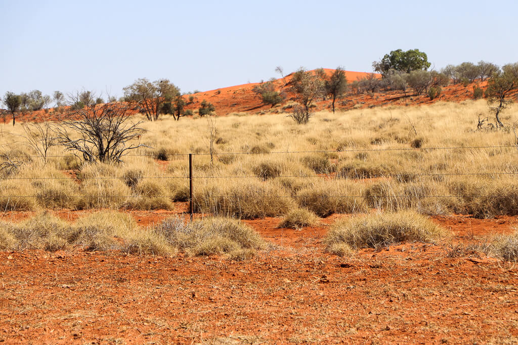
Tony and I travelled to Windorah from Quilpie, 246 km to the south-east, via the Quilpie-Windorah Road (State Route 14). The road is sealed, mostly single lane, with wide graded shoulders. On entering the Barcoo Shire, we were struck by the sight of the sandy orange-red soil and the sparse but beautiful grey-green vegetation.

About 30 km from Windorah we stopped to view the Dingo Barrier Fence. The fence is approximately 5400 km long. It starts at the Great Australian Bight just west of Penong in South Australia, passes through Cameron Corner (at the junction of South Australia and Queensland) and ends at Jandowae on Queensland’s Darling Downs. The fence aims to keep dingoes and wild dogs out of the sheep and cattle grazing country to the south of the fence. It was originally a rabbit proof fence, until top netting was added to provide a barrier for the dingoes and wild dogs. [5]

Nearly there: Cooper’s Creek
About 10 km from Windorah, we came to Cooper’s Creek (renamed Cooper Creek), a popular fishing and camping spot for locals and visitors alike. The creek is known for its fish (yellowbelly, bream and catfish) and crustaceans (yabbies, freshwater crabs and shrimp). We crossed the creek via a single-lane high-level concrete bridge.

Before the bridge was constructed over Cooper’s Creek, when the water level in the creek was high, people, goods and even stock were ferried across by boat. When the water level was low, from the 1920s, a man-made stone culvert allowed cars to cross the chain of waterholes. The bridge was built between 1946 and 1949.


Cooper’s Creek begins 35 kilometres to the north, at the junction of two rivers, the Thomson and Barcoo. During floods, floodwaters form myriad channels and floodplains extending from the banks of Cooper’s Creek for tens of kilometres. For this reason, Windorah is dubbed “The Heart of the Channel Country”.
Explorer Charles Sturt named Cooper’s Creek in 1845. He wrote: “Before we finally left the neighbourhood where our hopes had been so often raised and depressed, I gave the name of Cooper’s Creek to that fine watercourse we had so anxiously traced, as proof of my respect for Mr Cooper, the judge of South Australia. I would glad have laid this creek down as a river, but as it had no current I did not feel myself justified in doing so.” [6]
Innovation in the outback: The Windorah Solar Farm
A high-tech solar farm was the last thing we expected to see in this remote part of Queensland!
This was Surprise No. 1.
The Windorah solar farm, which consists of five huge mirrored dishes (each 13.7 metres in diameter), is located on land next to the diesel power station about 2 km from the town.
Commissioned in 2009, the Windorah solar farm is Ergon Energy’s first use of this innovative solar energy technology. Each dish contains 112 mirrors, which reflect and concentrate sunlight onto a high-capacity solar cell in a central point at the front of the dish. Each cell generates approximately 26 kW of electricity, depending on season, time of day and cloud cover. The dishes act like giant sunflowers, following the sun so that as much sunlight as possible falls on the mirrors. The Windorah solar farm generates enough energy to meet the town’s daytime electricity needs. [7]
The town’s aerodrome is across the road from the solar farm.


Arrival: Welcome to Windorah!
Visitors are truly welcome at this tiny far western Queensland town, judging by the number of roadside welcome signs! But, as well as the welcome signs, you are reminded just how isolated you are out here. Here are two examples:


Walking Together Park
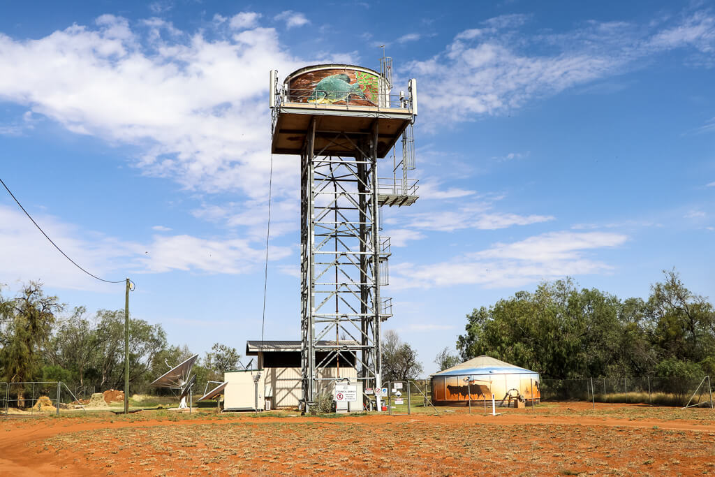
On the outskirts of town, we stopped to explore the Walking Together Park, a delightful nature and art display with installations by outback artists and members of the local community. The large fish mural, small mosaics and life-size sculptures aim to introduce visitors to the fauna and flora of the district. It’s well worth a wander.


Nearby, we spotted an elevated water tank, and reservoir, part of the town’s water treatment plant. Both feature stunning murals, one a big fish in water (a reference to the town’s name, Cooper’s Creek, fishing and tourism), the other red soil, dust, cattle and stockmen (representing the district’s beef cattle industry).

In town: Windorah Visitor Information Centre
As we drove into town along Maryborough Street, we couldn’t miss the Visitor Information Centre. It’s well-signed. The centre houses the town’s public library, provides guests with internet access, has souvenirs for sale and has a large supply of free brochures for visitors. The receptionist told us about the Nature Drive, the Walk Around Town and the Whitula Gate Museum (to name a few attractions). We left armed with several brochures to help us explore the town and district. But first, we checked into our accommodation, the Western Star Hotel.
Western Star Hotel
When we went into the hotel bar to inquire about our accommodation, we met the bar attendant – a young Irishman!
This was Surprise No. 2.
In his broad Irish accent, he told us that he and his wife were on a working holiday in Australia. At Windorah the couple were relieving the hotel owners who were taking a break for three months. We joked about the stark differences between Ireland and far western Queensland (Windorah in particular). Nevertheless, he insisted he and his wife loved Windorah and their work at the pub. He said they would do it all again, if they have the chance.
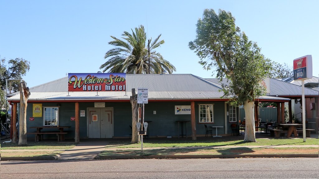
The Western Star Hotel is one of Windorah’s two original hotels. Its licence dates from 1878-1879. The actual date of construction is unknown, as is its builder. Most likely, brothers G J and C T Fitzwalter built it. Mr G J Fitzwalter was its first licensee. [8] Tom Costello built the Royal Hotel (later renamed the Cosmopolitan) around the same time. The Cosmopolitan Hotel eventually fell into ruin. Its site, next door to the Western Star Hotel, now houses a private residence.

The Western Star Hotel still exists on its original site in Albert Street. However, the current building is not the original. Fires in 1954 and 1956 destroyed the old pise (rammed earth) building. [9, 10] The current building, however, evokes its predecessor, with many timber features including rough-hewn log supports at the front of the building, timber tables and seating, and timber lining the bar area. The complex includes a roofed outdoor sitting area, separate licenced restaurant, undercover outdoor dining area and beer garden.


To accommodate visitors, the Western Star Hotel has six hotel rooms and four modern motel rooms, located in two separate buildings in its spacious grounds. We stayed in one of the motel rooms, the largest and most comfortable of all the motel rooms we encountered during our western Queensland trip. Well done, Western Star!
After settling into our accommodation, we headed back along the Quilpie-Windorah Road to begin the 12 km nature drive.
The Windorah Nature Drive
The 12 km Windorah Nature Drive was one of the highlights of our visit to Windorah. We highly recommend it. The Windorah Development Board established the drive to help people understand and appreciate the local environment, with its distinct natural vegetation and wildlife. You can start the drive just out of town and end up at Cooper’s Creek, or vice versa. We took the first option. We began the drive around 4.00 pm, and finished around 6.00 pm.
The route is signposted throughout. Besides several landmarks, the signs point to 38 different plant species (the common names are sign posted). As we meandered along the dirt track, we stopped to look at and photograph most, if not all, of these plants. The variety is truly amazing.

According to the brochure we picked up at the Visitor Information Centre, Cooper’s Creek floodplain has a number of distinctly different plant communities, including coolibah woodland, alluvial herbland, lignum shrubland, gidgee open woodland and spinifex grassland. The creek itself is lined with River Red Gum, Coolibah, River Tea Tree and wattles. [11]


One landmark, near the beginning of the drive, is the stock route water point. A sub-artesian water bore, drilled in 1970, provides water for cattle driven along the stock route.

Another landmark is a phone line. Built in the 1920s, it was a single party line connecting four properties to the manual exchange in Windorah. The exchange was only open between the hours of 8.00 am and 10 pm Monday to Saturday and between 9.00 am and 12.00 noon on Sunday. Out of hours the line was connected to another property in case of emergency. Of course, the phone line is no longer used. It’s a reminder of the (not-so-distant) past. Windorah gained an automatic telephone exchange after the post office and telephone exchange burnt down in 1990.

Of the six rules for visitors taking the nature drive, my favourite is this one: “Take away nothing but memories and photographs. Leave nothing but tyre tracks and footprints.”

Windorah’s vivid colour palette
By the time we reached Cooper’s Creek at the end of the nature drive, the sun was low on the horizon. The creek and the bridge had a splendid golden tinge in the late afternoon light. We spied a number of campers and day trippers in the distance.

Back on the highway, we encountered a herd of cattle being driven by young stockmen on motorcycles. The colours of the cattle, the roadside and the western sky at sunset were glorious. I tried to capture the beauty of the scene with my camera.


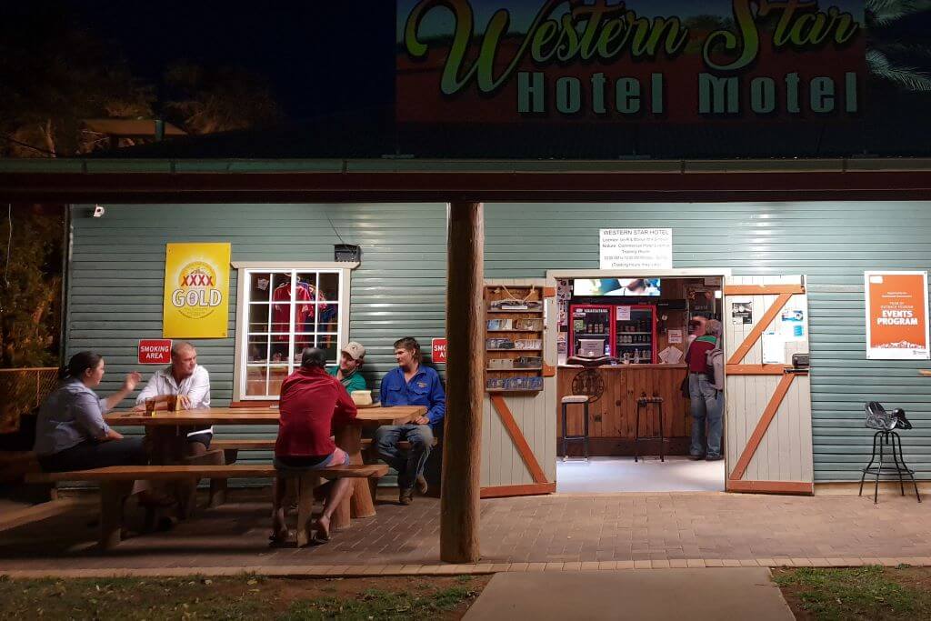
We returned to the Western Star Hotel, where we had our evening meal. Along with several locals and a sizeable tour group, we relaxed and enjoyed the Western Star’s laidback atmosphere and warm country hospitality.
“Walk Around Town”
We arose early the next day, keen to take the Walk Around Town. (We planned to follow the town maps we picked up at the Visitor Information Centre the day before.)
The day dawned sunny and clear. The bright sunlight accented the various colours and shapes of Windorah’s built environment and its expansive natural surroundings. As we were staying at the Western Star Hotel, we began the Walk Around Town near the hotel, at the corner of Albert and Maryborough streets.

Windorah Court House
This tiny building began its life in the 1880s as the Windorah Court House. [12] Originally situated in the Police Station yard, it was moved to this location, the corner of Albert and Maryborough streets, in the 1960s. For some years Channel Country Transport used it as a shed for its truck parts.

Until recently, one of Windorah’s local legends, Kevin Oates, (“Tarpot”, “Tarry” or “Pot” as he was commonly known) made the building his home. Mr Oates, who died on 13 October 2018, was born in the district and spent his entire life here. He was a highly respected stockman and drover. [13, 14]
At the time of our visit, in late 2019, “Tarpot’s Cottage” (as it is still known by the locals) lay vacant.
“Down-town” Windorah
In the middle of Albert Street, just off Maryborough Street, there’s a large rock, a monument to one Thomas Joseph Callaghan. It’s a poignant reminder of the district’s harsh conditions. The inscription on the plaque reads as follows:
In memory of Thomas Joseph Callaghan (1865-1888), Constable of Police, Queensland Police Force. On 30 November 1888, whilst travelling from Whitula Station to Windorah on official duty, Constable Callaghan died of thirst. His body lies in an unmarked grave 40 miles [approximately 64 kilometres] west of Windorah.

Windorah is laid out in 12 rectangular town blocks, separated by wide streets. Albert Street is the main street. It features a wide, lush grassed median strip, with large shady trees, tables and seating.
This was Surprise No. 3.

Given that much of western Queensland was experiencing a prolonged drought at the time of our visit, we didn’t expect to see lush green grass in Windorah. We were told it is possible because the town has an abundant supply of water from Cooper’s Creek. The creek was full at the time, due to flood rain in northwest Queensland early in 2019, floodwaters eventually finding their way into Cooper’s Creek.
One of Windorah’s annual events, the International Yabby Races, is conducted in this street, in front of the Western Star Hotel. The event is held in late August or early September, on the Wednesday night prior to the Birdsville Races (when lots of visitors are passing through, on their way to Birdsville). Unfortunately, due to the COVID-19 pandemic, the 2020 event has been cancelled.
Albert Street is the “business” hub of town. Here, in addition to the hotel, is Windorah’s general store, service station and post office.
Windorah Outback Shop
The Windorah Outback Shop is located at 16 Albert Street, across the road from the hotel. Here you can purchase a selection of groceries, gifts, refreshments, snacks and takeaways.

The store has a long history. Mr G J Fitzwalter opened Windorah’s first store here in 1879. [15] He later sold it to the entrepreneurial Whitman Brothers, of Wittown (Isisford), who put Mr L E Ashby in charge (Mr Ashby also took over as postmaster). [16] By 1883, Windorah had two stores, two hotels, a forge and wheelwright shop, and police barracks [17]:
The stores are owned by Messrs W and J Whitman, the Barcoo pioneers, and Mr T Costello, the hotelkeeper. Everything from a needle to an anchor can be procured in the township, and Messrs Whitman are erecting large receiving stores to meet the increased demands of the district. Messrs Whitman’s forge and wheelwright shop are situated at the entrance of the township, and four mechanics are continually employed. The timber is procured from the banks of the Cooper’s Creek billabongs and the carriers speak in high terms of its durability for wagon work. The buildings are principally composed of pise with iron roofs, and both in appearance and durability are little inferior to brick erections. There is a police barracks at the farther end of the town, at which three constables and one trooper are stationed.
Like most of Windorah’s early buildings, Fitzwalter’s store was made of pise (rammed earth). In 1885, the Whitman Brothers built a new and enlarged building, of galvanized iron. At the time, it was the only building on that side of Albert Street. [18]
Windorah Service Station
Windorah’s only service station is located at 12-14 Albert Street, on the corner of Albert and Virtue streets. It’s the last garage and fuel stop for 384 km (if you’re heading to Birdsville) or 388 km (if your destination is Bedourie).
Clearly, the service station is well patronized. We certainly stopped by here to fill our petrol tank before leaving Windorah and setting off for Birdsville.

You can like or follow the Windorah Service Station on Facebook (along with more than 5500 others). One happy customer wrote: “Great family run business with the best service and food in outback QLD. Worth stopping in.” Another satisfied customer wrote: “Can’t thank Peter and all the staff for an awesome level of customer care and willingness to go an extra mile for their visitors. Without you we wouldn’t be able to travel around our beautiful country. Thank you!”
Windorah Post Office
The Windorah Post Office is located over the road from the service station, on the corner of Albert and Virtue streets. The building used to be a café, but today it serves as the town’s post office and bank agency. In 2015, the Windorah Development Board bought the building and the town’s post office licence after the former post office went on the market and no buyers were found. [19] The former post office building is located in Maryborough Street, over the road from the Visitor Information Centre.

Windorah has had postal services since 1880. No wonder the people of the district didn’t want to lose this much-valued service. The Stoney Point Post Office opened on 8 October 1880. Mr G Fitzwalter, the Western Star Hotel publican, was the town’s first postmaster. [20] A telegraph line came to Windorah in 1885. The town’s new combined post and telegraph office building opened for business in August 1886. [21] It was made official in 1893, transferred to the Commonwealth on 1 March 1901, but reduced to unofficial status on 1 May 1979. [22]

Windorah State School
The Windorah State School is located at 8 Victoria Street. It caters for children from Prep through to Year 6. The current building dates from 1958. It was the former Yaraka school building, which was pulled down and rebuilt in Windorah, in time for the opening of Windorah’s full-time state school, on 3 February 1958. [23]

Windorah’s first school, a provisional school, opened on 30 July 1888. [24] It closed and reopened several times before closing on 31 December 1918. It reopened again as a provisional school in 1926. The original building had been sold in 1924, so in 1926 when the school reopened, classes were held in the newly erected Windorah Women’s Progress Club Hall. [25]
Over the road from the school is a well-equipped, undercover multi-purpose recreational area, for school and public use.
Windorah’s two church buildings
The town has two church buildings, Our Lady of Lourdes Catholic Church, located at 4 Victoria Street, and St Clare’s Anglican Church, at 14 Edward Street.
Our Lady of Lourdes Catholic Church, a little timber building with a galvanized iron roof, dates from 1939. [26] The building has been thoroughly renovated, commencing in 2015, by volunteers of various organizations – Queensland Police Service, Australian Defence Force, Queensland Health, to name a few. The refurbishment work was completed in May 2020. [27, 28]
The congregation of Windorah’s Catholic Church is part of St Finnbar’s Parish, Quilpie, and the Diocese of Toowoomba. A priest based at Charleville conducts services here on Mondays at 5.00 pm, every second month.

St Clare’s Anglican Church building was originally a local shearing shed. After being moved to its present site in 1972, it was converted to a neat and tidy chapel, with seating for 25 persons. The church is part of the Quilpie Parish of the Anglican Church of Southern Queensland.

Windorah Community Centre and Town Hall
The Windorah Community Centre and Town Hall, located at 6-10 Edward Street, is a substantial contemporary structure, quite unlike any other in this small outback town.
This was Surprise No. 4.
The building includes a hall and stage, meeting rooms, kitchen, toilets, showers and a gymnasium. Next door there’s a large sports ground. The Barcoo Shire Council built the multi-purpose complex in 2009 to replace an old hall that had been in use since 1927. [29]


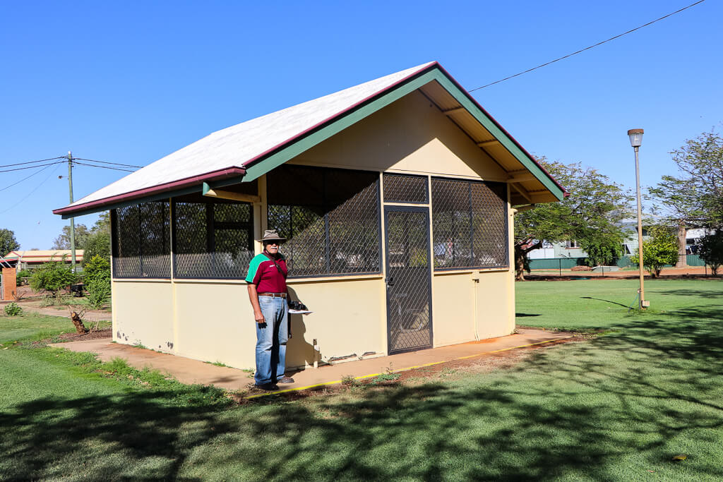
Rabig Park
Rabig Park is located at the corner of Albert and Maryborough streets. It’s a beautifully maintained green space in the heart of town.
Apparently, the area was declared a park in 1980 following the Windorah centenary, with development commencing in 1985. One of the residents informed me that the park is named after Herb Rabig, a keen naturalist and descendant of one of the district’s early resident families. Mr Rabig who, with his brother, owned Cuddapan Station, 160 km west of Windorah, was also a Barcoo Shire Councillor and Deputy Mayor for many years. [30]

Here, in Rabig Park, was Surprise No. 5.
The centrally located picnic tables and seats are under cover in a fully screened enclosure! You enter and leave the area via a screen door, which must remain closed. The flies must be bad here in the summer months.
Whitula Gate Museum
We concluded our Walk Around Town by visiting the Whitula Gate Museum. As well as being a popular tourist attraction, the museum is a tangible reminder for the district’s residents of its recent and ancient history.
The main feature is an old slab hut, built of local timber. Boundary riders built the hut in 1906 at Whitula Creek, 40 km west of Windorah. In 1994, in order to preserve the hut, the local Arts and Crafts Group moved the building to this site, piece by piece. The hut and its furnishings, antique household goods, shed, dunny and garden, together recreate an early 1900s homestead. [31]


The museum also includes an Aboriginal gunyah (or humpy), a temporary tent-like shelter, and an old boat.


The “Cooper Queen” is a large round bilge bottomed boat made of iron. In days gone by it was used to transfer people, stock and goods across Cooper’s Creek to and from Hammond Downs. Skippered by Billy Blake up until the 1950s, it was once used during a flood to transfer up to 96 sheep at one time!

On the edge of town: Rock of Remembrance, Costello Place
Before we left Windorah, en route to Birdsville, we stopped at the far end of Albert Street to view the Rock of Remembrance. It’s the community’s acknowledgement of the men and women of the Windorah district who served their country in World War I and World War II.
The monument contains four plaques. One lists the names of all those who served. Another indicates that the Rock of Remembrance came about after a meeting of the Windorah sub-branch of the Returned and Services League of Australia (RSL) held on 15 October 1967. A third plaque indicates that the Rock of Remembrance is recognised by the Stockman’s Hall of Fame, Longreach. A fourth plaque is dedicated to Thomas Joseph Costello, his wife Catherine Hackett, and their family, early European settlers of the district. The site, Costello Place, is named in their honour.

Beyond the town: On the road to Birdsville
Throughout our travels in Queensland’s outback, we stopped to view and take photographs of the magnificent scenery, historic sites and (wherever we could find them) wildflowers. As we left Windorah and headed towards Birdsville along the Diamantina Development Road, we made a number of such stops.
We didn’t have to travel far to be wooed by Windorah’s magnificent orange-red sand hills. In fact, the sand hills located on Ourdel Station, about 12 km west of Windorah, are one of the local tourist attractions. [32] There, from the top of the sand hills, apparently one has a 360 degree view of the surrounding area.
JC Hotel ruins
About 80 km west of Windorah, just off the Diamantina Development Road, lie the ruins of the JC Hotel, once part of the town of Canterbury. We stopped to take a look – not that there is much left to see. Today, there’s no hotel, just a mound of dirt. But there’s some really interesting history associated with this hotel, which served locals and travellers alike for seven decades.
Sometime before November 1881, Charles Manners opened the Jockey Club Hotel on this site. [33] Mr Manners held the licence of the hotel until 1886. [34] Although formally named the Jockey Club Hotel – later renamed the Waverney Hotel (after nearby Waverney Station) – the hotel was always referred to as the “JC”. Legend has it that the name “JC” comes from the initials of John Costello who supposedly stopped here and carved his initials into a coolibah tree (the tree has long gone). But it’s also possible that the popular name “JC” came from the initials of the hotel name. [35]
In the same year Manners opened his hotel (1881), a camping reserve was set aside by the local waterhole. [36] In 1884, surveyor G T Weale laid out a township and named it Canterbury. A postal receiving office opened in 1888. The postal service was elevated to a post office in 1891, reduced to a receiving office again in 1893 and finally closed on 19 March 1920. [37]

The JC Hotel closed in 1956. Soon afterwards, its iron roof was removed. Like many of Windorah’s early buildings, the JC Hotel had been constructed of pise, the walls marked and painted to resemble large rectangular stone blocks. Once the roof was gone, the earthen walls began to crumble, until today all that remains is a mound of dirt, scraps of iron, and broken glass.

Native Wells
Before leaving the Windorah district, we made one more sightseeing stop. Approximately 90 km from Windorah, we spied the native wells, not far from the road. Aboriginal people used these wells as their source of water for centuries. Although wells in outback Queensland are dry most of the time, during a wet season water filters through cap rock and pools in the natural depressions, which can be accessed by people and animals alike.

By this stage on our journey, we noticed the marked difference in the terrain. Here the ground was hard, not sandy, and we saw the shiny red-brown pebbles (“gibbers”) for the first time. We realized this was the beginning of the stony downs or gibber plains of the Sturt Stony Desert, which extend from this part of far western Queensland to the north eastern corner of South Australia.

Your virtual tour of Windorah is over.
I hope you enjoyed your visit as much as we did.
Tony and I were so rapt with what we saw and learnt during our visit to Windorah, we plan to return this year. Although for this year’s outback Queensland trip we are heading to Queensland’s northwest region, we plan to return to Brisbane via the Barcoo Shire, visiting Jundah and Stonehenge, as well as Windorah.
What surprises lay in store for us this time? We can’t wait to find out.
REFERENCES
- Australian Bureau of Statistics (ABS). 2016 QuickStats: Windorah. Online: Retrieved on 17 May 2020.
- Barcoo Shire Council. (Undated, current). Heart of the Channel Country: Jundah, Stonehenge, Windorah. (Promotional booklet). Barcoo Shire Council.
- Australian Bureau of Statistics (ABS). 2016 QuickStats: Barcoo Shire. Online: Retrieved on 17 May 2020.
- (1936). Courier-Mail (Brisbane, Qld. : 1933 – 1954), Thursday 24 September, page 14. Online: Retrieved on 17 May 2020.
- Barcoo Shire Council. Dingo Barrier Fence. (Information sign).
- Sturt, Charles & Brown, Robert. (1849). Narrative of an Expedition into Central Australia. T & W Boone, London.
- Ergon Energy. (Undated). Windorah solar farm a beacon of light. (Information brochure). Ergon Energy Network.
- Frew, J. (1981). Queensland Post Offices 1842-1980 and Receiving Offices 1869-1927 / Joan Frew. Online: Retrieved on 18 June 2020.
- Windorah Hotel – After the fire. (1954). Courier-Mail (Brisbane, Qld. : 1933 – 1954), Saturday 16 October, page 3. Online: Retrieved on 18 June 2020.
- Western Star Hotel. (Undated). A brief history of Windorah. Information sheet provided for guests of the Western Star Hotel.
- Windorah Visitor Information Centre. (Undated). 12 km Nature Drive Windorah. (Information sheet). Barcoo Shire Council.
- Country News. Windorah. From our own correspondent. (1883). Western Champion (Blackall/Barcaldine, Qld. : 1879 – 1891), Friday 26 October, page 3. Online: Retrieved on 18 June 2020.
- Windorah Community Events. Facebook. Community. Online: Retrieved on 10 June 2020.
- Mayor’s Message. (2018). Barcoo Shire Community Newsletter. Issue No. 161, October 2018. Online: Retrieved on 10 June 2020.
- Notable Firm. (1925). Brisbane Courier (Qld. : 1864 – 1933), Friday 6 March, page 13. Online: Retrieved on 11 June 2020.
- Sixty years in Queensland. Memorable Pioneers. By J T S Bird. No. 70. William Whitman. (1925). Capricornian (Rockhampton, Qld. : 1875 – 1929), Friday 25 September, page 64. Online: Retrieved on 18 June 2020.
- Windorah. (1883). Morning Bulletin (Rockhampton, Qld. : 1878 – 1954), Wednesday 23 May, page 3. Online: Retrieved on 10 June 2020.
- The Sketches. Western Scenes and Sketches. By Overlander. 1. Windorah Past and Present. (1886). Queenslander (Brisbane, Qld. : 1866 – 1939), Saturday 11 September, page 13. Online: Retrieved on 18 June 2020.
- Moore, Ash. (2015). Windorah mail service saved as remote western Queensland town buys post office licence. ABC News. Online: Posted on 24 July 2015. Updated on 14 September 2015. Retrieved on 10 June 2020.
- Frew, J. (1981). Queensland Post Offices 1842-1980 and Receiving Offices 1869-1927 / Joan Frew. Online: Retrieved on 18 June 2020.
- Colonial and Intercolonial. From our special correspondents. Queensland, Windorah. (1886). Western Champion (Blackall/Barcaldine, Qld. : 1879 – 1891), Tuesday 10 August, page 3. Online: Retrieved on 11 June 2020.
- Frew, J. (1981). Queensland Post Offices 1842-1980 and Receiving Offices 1869-1927 / Joan Frew. Online: Retrieved on 18 June 2020.
- Windorah State School. Queensland State Archives. Online: Retrieved on 18 June 2020.
- Western Star Hotel. (Undated). A brief history of Windorah. Information sheet provided for guests of the Western Star Hotel.
- Windorah. New Hall Opened. (1927). Longreach Leader (Qld. : 1923 – 1954), Friday 30 September, page 1. Online: Retrieved on 10 June 2020.
- Forrest, P., Forrest, Sheila, & Barcoo Shire Council issuing body. (2014). Their Promised Land : A History of the People and Places of the Barcoo Shire, Western Queensland / Peter and Sheila Forrest.
- Moore, B. & Mounter, B. (2015). Breathing new life into Windorah’s old Catholic church. ABC News Western Queensland. Online: Posted on 28 May 2015. Retrieved on 17 May 2020.
- Fitzsimmons, C. & Prosser, D. (2020). Soldiers on coronavirus checkpoint duties delight tiny outback town with church makeover. ABC News. Online: Posted 4 June 2020. Retrieved on 7 June 2020.
- Windorah. New Hall Opened. (1927). Longreach Leader (Qld. : 1923 – 1954), Friday 30 September, page 1. Online: Retrieved on 10 June 2020.
- Facebook. Public group. Online: Retrieved on 1 June 2020.
- Windorah Information Centre. (Undated). Welcome to Windorah. (Visitor information sheet). Barcoo Shire Council.
- Windorah Sand Hills. Outback Queensland. (Website). Online: Retrieved on 18 June 2020.
- Forrest, P., Forrest, Sheila, & Barcoo Shire Council issuing body. (2014). Their Promised Land : A History of the People and Places of the Barcoo Shire, Western Queensland / Peter and Sheila Forrest.
- Ibid.
- Ibid.
- Frew, J. (1981). Queensland Post Offices 1842-1980 and Receiving Offices 1869-1927 / Joan Frew. Online: Retrieved on 18 June 2020.
- Ibid.


A first rate Posting…..Read. Brings back memories of my wanderings through the late 60’s, and early 70’s. Thank you very much.
Dear Graham. Thank you so much for your feedback. I am encouraged that my story brought back so many memories for you. Kind regards, Judy.
I use to shear around windorah in the 80 at a place called tenan great memories
Hi Judith – What a very informative and pleasant story on Windora and your experiences there – I really enjoyed it. I’m currently in the final stages of planning a 2 1/2 week road trip from Brisbane to Longreach / Winton so it was a very timely read. We are travelling out from Brisbane via Carnarvon Gorge but I’m still open to options for our return leg. After your story I’m leaning to route 79 taking in Windorah and also Stonehenge and Jundah then the Diamantina Rd to Eromanga (for the dinosaur and natural history museum) and Quilpie. I’m Interested if you have traveled that track yet and if so do you have any notes / tips you can share.
PS Also enjoyed your story on the North Gregory Hotel 🙂
Hi Judy Another outback beauty. These towns must be an eye opener for Tony
especially. You and I have had an idea of these places but Tony would be
I guess a little amazed by the character of these towns. I did like the Solar Panels at the entrance to the town. Always things a little different in these outback places. Every town has there own special themes.
Thank you for another of your outback experiences.
Margaret and Neville
I love that area. Have done several trips, the first after coming up from Innaminca on the Cordillo Downs road. We reached Windorah after dark, and went straight to the Service Station for repair of a damaged tyre. The proprietor of the service station was a blind man, but this did not prevent him from changing a tyre for us. He sat on a stool with the wheel / tyre between his knees, requiring minimal help. He was a legend out there for a number of years. For fuel, after you had filled up, he would ask you to read the amount on the pump, and he would then take your money, all the time staring straight ahead, and it ultimately would dawn on you that he could not see.
Hello Judy,
In the process of establishing “Far West Outback Epic Drives” after completing “South West Outback Epic Drives”.
In the documet “Things to See & Do” under the heading “Windorah” a link to this wonderful article.has been listted.
If interestedn can forward a rough draft copy for your review.
I loved reading your detailed story of Windorah, Judy. We stayed overnight in the tourist park and only briefly noted some of the points of interest that you have written about. Today we travelled from Windorah to Bedourie and i loved the changing landscapes. It was very dry and barren but the sandhills and different coloured soils and stones were interesting. Thanks for including the history of Windorah.